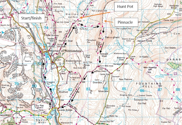
At a height of 2,277 feet (694 meters) Pen-Y-Ghent is the lowest of the three peaks of Yorkshire and along with Whernside and Ingleborough dominates the sky line in upper Ribblesdale. I've walked all three many times in the past. Sometimes individually and sometimes together as part of the 25 mile three peaks walk. Out of the three, which all have their own very different characters, Pen-Y-Ghent has always been a firm favorite.
There are many reasons why it's my favorite, some of which are deeply personal. There's the hill itself which I find particularly aesthetically pleasing, reminiscent as it is of a crouching Lion in profile.
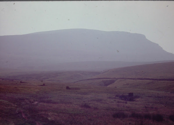
Pen Y Ghent from Horton in Ribblesdale. Left in 1972, right in 2021
Pen-Y-Ghent was also the first fell/hill of any significance I ever walked on a hot summers day in 1972. My brother and I were only young boys and we had a fantastic day exploring the likes of Hull pot and the rock pinnacle which stands on the western flanks over looking Ribblesdale. Even now some fifty years later I can still smell the moorland and feel the heat of that day.
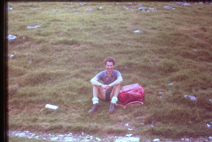
The fact is Pen-Y-Ghent had been an influential factor in our family long before my brother and I were even born. My dad grew up in post war Britain in a pit village where life was hard, particularly if like my grandmother you were a single parent. Her husband (my grandfather) having been killed in the war. Against all odds however, dad won a place at what was then considered to be one of the best grammar schools in the area and his horizons were expanded beyond the pit heaps of County Durham.
It was on a school trip in the early 1950's when he first experienced the Yorkshire Dales and I think it was fair to say it was love at first sight. Especially when it came to Pen-Y-Ghent which he and his class mates had enthusiastically walked/explored. I don't think he ever forgot that day and he often reminded us of how he and his friends climbed the pinnacle (unlike today this wasn't frowned upon in 1950) or slithered their way down into Hull Pot. Thinking about it once his boys were old enough there was only ever going to be one destination for their first hill walk.
One way or another Pen-Y-Ghent played a significant role in kindling two generations love of the out doors. Sadly dad was taken from us in the early 80's. We scattered his ashes close to the pinnacle on the hill he loved so much.
JRN "Nick" Bainbridge doing what he loved best.
Over the years I walked and explored this hill on numerous occasions, both on my own or with my wife and brother. Needless to say I've seen both the best and the worst of it and believe me the way the weather changes in this country you can go from one to the other in a blink of an eye. I was once told there used to be a prehistoric settlement on the summit. Whether this is true or not I don't know, but if it was, it's inhabitants were hardy so and so's that's for sure.
In the winter of 2009 my wife, daughter, brother and I walked the hill on a glorious, albeit snow covered, day. I didn't know it at the time, but this would be the last time I would stand on it's summit for another twelve years. Initially work would take me away from the area and then illness would take it's toll. So much so I firmly believed I would never be capable of walking three or four easy miles let alone a hill walk in the Dales.
The illness/condition which I've had the misfortune to be inflicted with is Chronic Sarcoidosis which is documented elsewhere on this blog. The upshot is my breathing/ lung capacity is rubbish and the slightest rise in elevation has me wheezing like an old man. Or it did, once again as documented in this blog come November last year I decided to do something about it and started walking again. It's hard to think some eleven months later how hard it was to walk the dog a mile and a half around the local lanes.
Gradually over time a mile and a half became three, then one day I managed the heady distance of five miles which was a big milestone. I started to set myself goals and by that I mean achievable goals. 8 miles, 10 miles. Walking from my home to Staindrop, walking to Sunderland Bridge via the Weardale way. All of these were achieved. There was one goal however, or I should say half goal which I still had in the back of my mind. If I was being honest I thought it was beyond me, but if the chance arose I was going to give it ago and hopefully stand on the top of Pen Y Ghent once more.
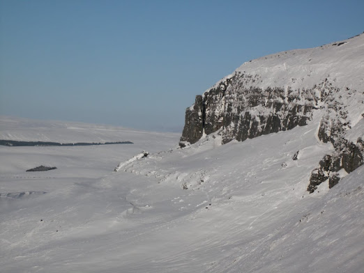
Pen-Y-Ghent in wintry conditions.
The chance presented itself in July of this year when Rob suggested a hike in the the Yorkshire Dales. After some deliberation we settled on Pen-Y-Ghent. I think Rob was a bit worried I would struggle, as was I, but as I said at least if we were together I wouldn't be struggling on my own.
It was a pleasant if not slightly overcast Sunday morning when I met up with Rob and my nephew Mike in Horton In Ribblesdale. Even though we had opted for an early start the council owned car park (where the public toilets are situated) was already full. There was however another car park on Station Road between the Crown Hotel/river bridge and the railway. This is a privately run affair in a farmers field, the parking fee being cash only, so go prepared as to my knowledge there is no cash machine in the village..
The route we'd chosen to take was the same one we took in the summer of 2006 which is as follows:-
- Leave Horton in Ribblesdale heading north east on Horton Scar Lane.
- Continue on Horton Scar Lane for approx 1.5 miles until the open moorland of Horton Moor is reached.
- At this point we made a diversion to see Hull pot and continued in a north easterly direction for three or four hundred yards.
- Having visited Hull Pot we then retraced back to the main path where Horton Lane met Horton Moor.
- Once back on route we headed due east on the Pennine Way toward Pen-y-Ghent.
- Continue on the well marked and apparent path up the slopes of the fell to the summit.
- At grid ref 838/742 the path makes a sharp right turn and heads south as it climbs to the summit.
- Once over the summit descend heading due south on the Pennine Way. Warning steep descent which might not be for everyone as some limited scrambling is required.
- At grid ref 835/718 turn right on Long Lane (the opposite direction to the Pennine way which turns left toward Fountains Fell) heading toward Helwith Bridge.
- At Helwith Bridge turn right up the lane toward Arcow Quarry.
- After appox 400 yards turn right and follow the riverside path back to Horton in Ribblesdale.
- Distance (as recorded on my tracker) 9.95 miles.
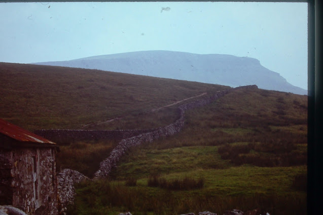
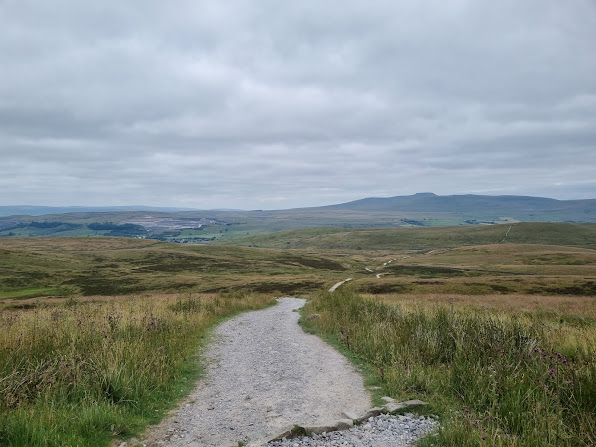
The route starts with a 1.5 miles drag up the picturesque Horton Scar Lane. When we first walked this way in 1972 the limestone surface of which had been polished smooth by countless pairs of boots. This seems to be less evident today, partly because of the loose aggregate which appears to have been added in an effort to combat erosion and partly because my memory is doubtless exaggerating things in my mind. I don't know why, but this is always my least favorite part of the walk even though there are some good views across an ancient river bed which like much of the surrounding landscape was carved out during the last ice age.
Taken from the end of Horton Scar Lane in 1972. The small barn in the bottom left corner of the picture no longer exists with little left to show it was ever there.
Under normal circumstances we would have made a right turn at the end of Horton Scar Lane and followed the Pennine Way directly onto the fell side. Today however, we'd elected to make a small detour and visit Hull Pot which is the largest naturally formed hole in England.
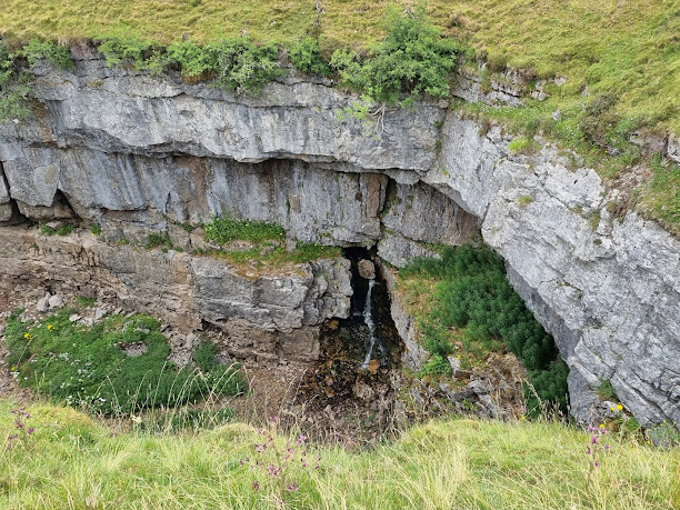
Hull pot is something in the order of three hundred foot long and sixty feet deep and is the result of water eroding the soft Carboniferous Limestone over millions of years. Indeed there are many pot holes and cave systems to be found within the Dales as a whole, some of which my brother and I explored with dad back in the late 70's.
Many years ago we scrambled our way down Hunt Pot and explored a cave which if I remember rightly ran for a short distance directly under the aptly named Hull Pot Beck. I wouldn't recommend doing this without the proper safety equipment though.
Two views of Hunt Pot. There have been winters when I've seen this half full of water.
Our visit to hull Pot concluded we retraced the three or four hundred yards back to the Pennine way and started our ascent of the fell side. Once again memory's of years gone by came flooding back. The first time we came this way this was a narrow path worn into the peat which threaded its way through numerous grouse shooting butts. The butts are still there only there at a safer distance from the path. On the numerous occasions I've walked Pen-Y-Ghent I've never once seen anyone grouse shooting. It must happen though so I would say its probably best to avoid the glorious 12th (of August) which is the first day of the shooting season.
The path wending its way through the shooting butts in 1972. Compare the difference with the state of the path back then and the present day path in the picture below.
I must admit owing to my condition I found the ascent hard going and had to stop at frequent intervals to catch my breath, but kept going nevertheless. I'd made my mind up when we first set off that even if I didn't make it to the top I was making it to the pinnacle where we scattered dads ashes nearly forty years ago.
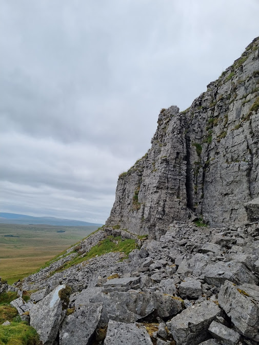
The pinnacle is to be found close to the point where the path makes a sharp right turn for it's final climb to the summit. Instead of turning right, turn left and pick your way for a short distance along the bottom of the scar and you will come to it.
Two pictures of the pinnacle on the western flanks of Pen-Y-Ghent
The path climbs steeply up the western flank of Pen-Y-Ghent although once again in an effort to halt erosion there is a good path with proper steps in place which whether you like them or not are there for a purpose. Once again I was panting away like an old stream train, but with some determination and no little patience on Rob and Mike's part made the summit. Unfortunately as so often happens the weather closed in on the top and robbed us of panoramic views across Ribblesdale to distant Ingleborough so have substituted this photo taken in the winter of 2009 with a zoom lens.
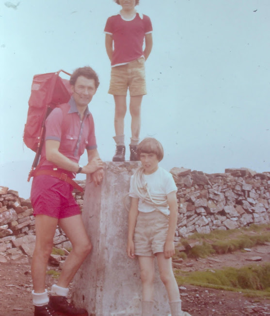
Dad, myself and my brother Rob on the top of Pen-Y-Ghent in 1972. No... I don't know why I was carrying a rope either. Full marks to my mum for chopping Rob's head off though.
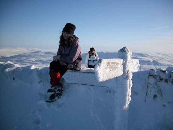
My wife and daughter on the summit on a somewhat colder day nearly 4 decades later.
Once over the top we followed the Pennine Way due south down the steep, rocky descent which involves a little scrambling, but nothing serious. When we were kids we felt like proper mountaineers scaling these dizzy heights, although we did live in pan flat Norfolk at the time. It's not everyone's cup of tea however, and on the day there was a lady who was far from happy and literally slid down on her backside. On a good day there a some excellent views across to Fountains fell to the east and also over the Ribble valley toward Helwith bridge and beyond.
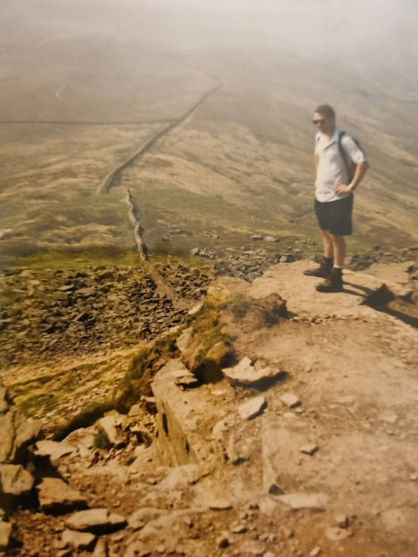
Rob making the steep descent off the southern end of Pen-Y-Ghent in 2006
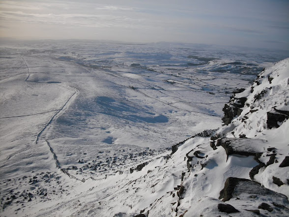
The same view in the winter of 2009.
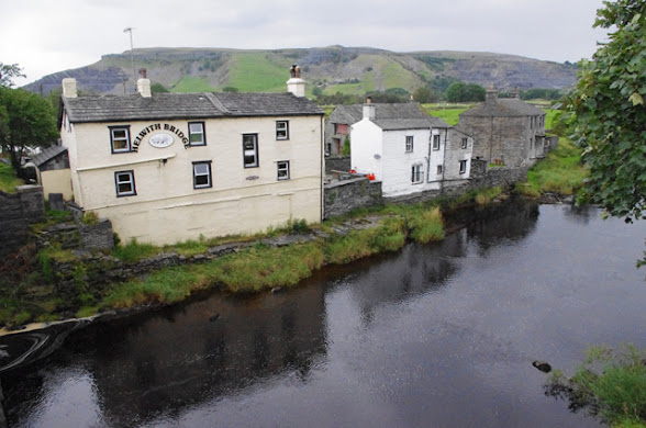
Now it's confession time. Rob and I walked the same route in 2006 and for some reason had it in our heads it was roughly six miles in length. Something we rapidly started to reassess on the descent of the aptly named Long Lane toward Helwith Bridge. Perhaps it seemed a long way as by this time we were all looking forward to a meal and some liquid refreshment. Needless to say every time we crested a brow three pairs of eager eyes were searching the countryside for the small hamlet of Helwith Bridge and more importantly the Inn of the same name. Going back to what I said about thinking the route was six miles in length, it's not, it's ten.
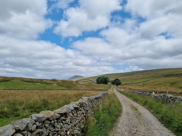
Looking back along Long Lane with Pen-Y-Ghent in the distance.
Helwith bridge Inn, good food and beer, well worth the visit.
I think its fair to say we were all starving. I know I was and I thoroughly enjoyed my gammon and eggs washed down with an ice cold pint, so much so I couldn't envision doing this walk again without making a similar stop.
From Helwith bridge we headed north up the tarmac road which leads to Arcow quarry before turning right onto a public footpath which passes under the railway. This is a very picturesque part of the walk as it wends its way across flood meadows with the river anon one side and the railway on the other. To the East Pen-Y-Ghent dominates the skyline whereas to the west the view becomes more industrial with views of extensive quarrying operations both past and present.
I have to admit I was feeling it a bit over the last mile or so and whilst it was true I had recently walked further it was on much flatter terrain. It had been good to be back on the fells again and Pen-Y-Ghent in particular which invoked so many happy memory's. Also it was another goal achieved, which given a year ago I was out of breath after walking a pan flat mile, was no mean feat. I suppose all that remains now is to thank Rob and Mike for putting up with me and set some more...
All photo's Peter/Robert Bainbridge


Comments
Post a Comment